
For those who are into this, these two maps are significant old gems. Unfortunately, I won't be bidding, unless a lottery win drops in my lap. But nice to enjoy anyway.
(both can be viewed in high resolution on auction web site)
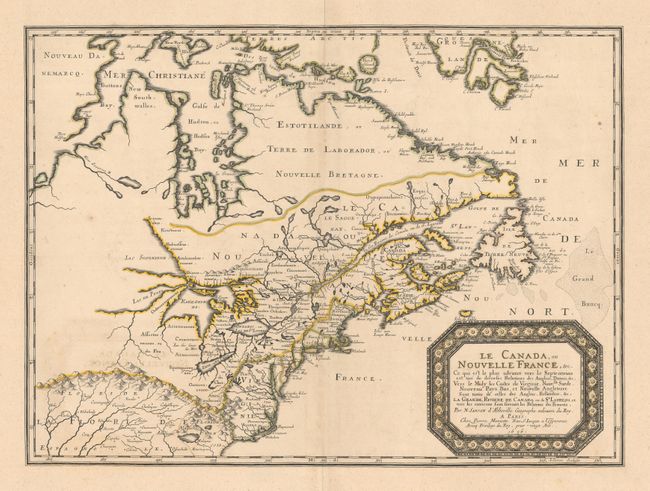
This one, a Canadian icon - the first, some would ague - to show and name all the Great Lakes, even though superior and Michigan are open ended.
Nicolas Sanson, "Le Canada ou Nouvelle France" 1657, estimate of USD $4,000 - $5,000
- Exaggerated French claim to large eastern North American territory
- New York in the hands of the Dutch
- Mississippi not yet known.


A map known as "The Beaver Map" by Herman Moll 1719, estimate of USD $17,000 - $20,000
- Key feature is the insert graphic of beavers working in a assembly like fashion felling trees, carrying stick and mud, to construct a dam, with Niagara Falls in the background.
- British territory greatly expanded after treaty of Utrecht.
- French claim to Louisiana
.jpg")

(both can be viewed in high resolution on auction web site)
This one, a Canadian icon - the first, some would ague - to show and name all the Great Lakes, even though superior and Michigan are open ended.
Nicolas Sanson, "Le Canada ou Nouvelle France" 1657, estimate of USD $4,000 - $5,000
- Exaggerated French claim to large eastern North American territory
- New York in the hands of the Dutch
- Mississippi not yet known.
A map known as "The Beaver Map" by Herman Moll 1719, estimate of USD $17,000 - $20,000
- Key feature is the insert graphic of beavers working in a assembly like fashion felling trees, carrying stick and mud, to construct a dam, with Niagara Falls in the background.
- British territory greatly expanded after treaty of Utrecht.
- French claim to Louisiana


Comment